


Természetjáró, a túratervező
Opis aplikacije Természetjáró, a túratervező
Туристички водич Мађарске на мрежи, посебно развијен за планинаре, бициклисте, трејлере, пењаче и љубитеље водених спортова, са уграђеним планером обиласка, као и стотине препоручених тура и хиљаде знаменитости, све са детаљним описима и обиљем фотографија , удобно видљив на интерактивној мапи. Доступно бесплатно, са опцијом претплате за проширену функционалност.
Карактеристике
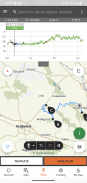
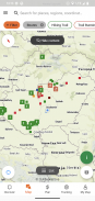
• Разне интерактивне, зумиране, векторизоване, светске планинарске мапе са свим обележеним стазама, које приказују вашу тренутну позицију
• Погодан начин да испланирате свој обилазак на мапи и одмах добијете дужину, трајање и профил надморске висине
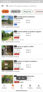
• Више од хиљаду препоручених тура за планинаре, бициклисте, тркаче и кануисте, са практичним подацима, детаљним описом најбољих знаменитости у близини, природном и културном позадином, квалитетним фотографијама и информацијама о томе како доћи
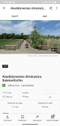
• Хиљаде препоручених знаменитости у Мађарској, укључујући видиковце, природне панорамске тачке, шумске возове, тврђаве и музеје, са детаљним описом, фотографијама доброг квалитета, као и информацијама о томе како доћи
• Стотине смештај, укључујући колибе, туристичке хотеле и апартмане, у близини обележених стаза
• Корисне збирке са погледом на мапу: плаже око језера Балатон, арене за клизање, ботеничке баште, најбоље стазе за трчање, места за пењање, туре за особе са инвалидитетом итд.
• Обавештења, упозорења и затварања
• Преузми одељке мапе, обиласке и знаменитости за коришћење ван мреже
• навигација у покрету дуж руте са профилом надморске висине уживо и гласовним упутствима
• Снимите своју руту
• БуддиБеацон: поделите своју позицију са пријатељима уживо
• Комплетна Мађарска плава тура, са званичним деоницама и рутом, ПОИ и смештајем
• Синхронизујте сав свој садржај између рачунара и мобилних уређаја који користе апликацију
• Проверите локалну временску прогнозу
• 3Д-лет: виртуелни поглед на обилазак из птичје перспективе
• Уграђени корисни алати, као што су проналазач врхова(Скилине) и компас са вашом тренутном позицијом
• Услуге у заједници: оцените и делите садржај са пријатељима
Паметни сатови са ВЕАР ОС-ом од Гоогле-а
Када погледате свој паметни сат, добијате информације о свом ГПС положају на мапи. Можете да снимате стазе, добијате податке о праћењу и навигирате дуж рута. Користите плочицу апликације за лак приступ оближњим рутама.
Искључиво за Про чланове
Идите било где: Оутдоорацтиве Про ради ван мреже без мобилног сигнала и сигнала за пренос података. Такође се могу креирати неограничене листе и апликација је без огласа. Поред тога, можете да видите сателитске снимке, јединствену Оутдоорацтиве мапу са преко 30 мрежа стаза активности и званичне топографске мапе следећих провајдера:
Греат Бритаин Орднанце Сурвеи, Ландрангер, Екплорер
Информације о земљишту Новог Зеланда
Утах УСГС
Немачка БКГ
Аустрија БЕВ
Свитзерланд свисстопо
Француска ИГН
Шпанија ЦНИГ
Италија
Холандија ПДОК
Норвешка Картверкет
Данска Кортфорсининген
Шведска Лантматериет
Финска Натионал Ланд Сурвеи
Јапан ГСИ
Глобал Мап
Искључиво за Про+ чланове
Про+ такође садржи званичне мапе алпских удружења као и премиум карте КОМПАСС-а.
Ако имате питања или сугестије, посетите
хттпс://ввв.термесзетјаро.ху/ху/п/гиакран-исметелт-кердесек/41050512 /
Наша десктоп верзија:
хттпс://ввв.термесзетјаро.ху/
Пратите нас на Фејсбуку:
хттпс://ввв.фацебоок.цом/Термесзетјаро.ху/
Контактирајте нас:
термесзетјаро@термесзетјаро.ху
Више о ТЕКА картици:
хттп://ввв.термесзетјарокартиа.ху/
Természetjáró, a túratervező - Informacije o APK datoteci
Verzija APK datoteke: 3.19.4Paket: com.outdooractive.mtszPoslednja verzija aplikacije Természetjáró, a túratervező
Druge verzije


Aplikacije u istoj kategoriji

Možda će vam se takođe dopasti i...


